Lam Dong has certified 33 agritourism sites; only 17 still operate. A project on Dai Ninh Lake bets on reversing the order — settle residents who farm, then bring in visitors.
Lam Dong is where agritourism in Vietnam started earliest and went furthest. The province has certified 33 agritourism sites. Today only 17 are actually operating — more than half have shut.
That figure is worth pausing on, because it does not reflect a shortage of visitors. Da Lat and its surroundings have never been short of visitors. It reflects something else: the small-farm-opens-its-gate model has hit a ceiling, and the ceiling sits somewhere most people would not look.
Why small sites struggle to scale
In April 2021 the Lam Dong provincial authorities issued Decision 933, an interim framework for investing in and managing agritourism businesses. It set a minimum site area of 0.5 hectares in Da Lat and 1 hectare elsewhere in the province, and capped the share of land that could be converted from agricultural to non-agricultural use for infrastructure at 3–5% of the total area.
The cap is sound in intent: it stops farmland from quietly becoming building land under the banner of tourism. But applied to a one-hectare garden, 3–5% leaves 300 to 500 m² for all infrastructure — enough for a reception building, toilets and a produce stall. Not enough for accommodation.
Without accommodation, visitors take their photographs and leave the same day. Revenue is confined to entry tickets and whatever produce sells at the gate. That is the model's natural ceiling, and the reason many sites opened and then quietly closed. The interim framework lapsed in December 2023; three new sites were certified during 2024, but the underlying problem remains.
The project under study at Dai Ninh Lake approaches it from the other end. Rather than expanding a farm into a visitor attraction, it plans a residential area with farming built in from the start, then places tourism services on top of that base.
The site: a peninsula in a 4,000-hectare lake
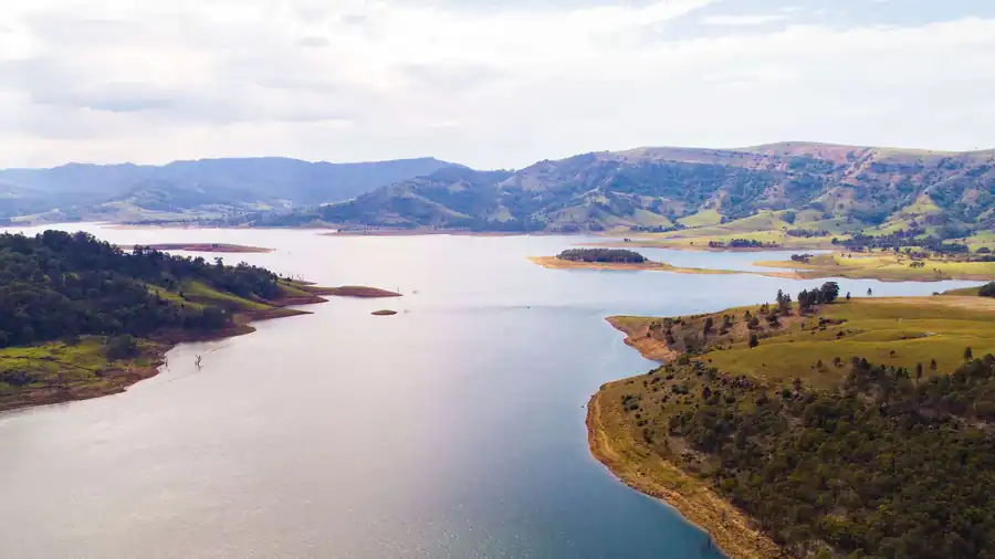
Dai Ninh Lake is the reservoir of the Dai Ninh hydropower plant on the Da Nhim River — 300 MW across two units, begun in May 2003 and completed in March 2008. The lake covers roughly 4,000 hectares of water with a storage capacity of 319.77 million m³. It lies close to National Highway 20, about 40 km south of central Da Lat.
The study area covers 690,853 m², or 69.1 hectares — around one sixtieth of the lake's own water surface. It occupies a peninsula in Ta Hine commune, Duc Trong district, with water on three sides (north, east and west) and existing hills and farmland to the south.
The peninsula form delivers two things a roadside farm cannot. First, a long waterfront: enough shoreline for a lakeside park, a marina and water-based activities. Second, a natural boundary — the project abuts no residential area on three of its sides, so its setting does not depend on what a neighbour decides to build.
This is also the Lam Vien plateau, mild in climate all year. Those conditions support both high-value agriculture and long-stay guests — two things most locations have to choose between.
An infrastructure advantage that gets little attention
Lien Khuong International Airport sits in the same district as the site. It is the Central Highlands' first international airport, rated 4E, designed for five million passengers a year. Its upgrade programme carries a total investment of roughly VND 7,748 billion — VND 4,591 billion through 2030 and VND 3,157 billion through 2050. The planned Dau Giay–Lien Khuong expressway will shorten the road approach from the south.
This matters more than it appears. Most of Lam Dong's agritourism sites cluster around Da Lat, which means visitors fly into Lien Khuong, travel roughly 30 km up to the city, and only then fan out. A project in Duc Trong puts guests essentially at their destination when they land — with no need to join the weekend traffic climbing to Da Lat.
For international visitors and long-stay guests, the distance from airport to bed feeds directly into the booking decision.
The new Lam Dong province: highlands to coastline
In 2025 Lam Dong merged with Binh Thuan and Dak Nong to form an enlarged province of 24,233 km² and 3,324,400 people, administered from Da Lat.
That change underpins something which previously required inter-provincial coordination: Dai Ninh Lake and the Phan Thiet–Mui Ne coast now sit inside the same province. A forest–lake–coast itinerary becomes a matter of provincial planning rather than negotiation between two administrations. For a long-stay highland property, the ability to send guests to the sea and back within a day is a genuine advantage rather than a marketing line.
Three offers for three audiences
The plan does not commit to a single format. It divides tourism into three offers, each with its own allocation of land.
Glamping takes 94,528 m², or 13.7% of the site — the largest of the three. Accommodation is in dome cabins and tents, supported by infrastructure for outdoor activities and events. The audience is younger, travelling in groups, staying briefly, concentrated at weekends.
Agricultural tourism takes 75,777 m², or 11.0%. This is where visitors join the working life of the site: flower and herb gardens, a petting zoo, an apiary, a café among the plots, plus water-based activities such as boating and fishing.
Wellness and resort services take 65,378 m², or 9.5%, serving long-stay guests. The offer comprises bungalows, small villas and single-storey apartments for older residents, alongside a spa, meditation space, swimming pool, library, restaurant, gym and yoga studio.
Splitting the offer three ways addresses seasonality. Glamping fills at weekends and in the dry season. Wellness guests stay long and care little which day of the week it is. Agricultural visitors follow the harvest calendar. Because the three streams peak at different times, shared infrastructure — roads, water supply, wastewater treatment, restaurants — does not sit idle through the low season. A standalone farm site cannot spread its fixed costs that way.
The lakeside strip is planned as a light park, giving the area an evening character. It is a small detail in the right place: most highland destinations go quiet after dark, and overnight guests need a reason to stay rather than drive back to the city.
Housing is what holds the model up
After internal roads, the largest allocation is garden housing: 135,248 m², or 19.6%. Plots are generous, 500 to 800 m² each — enough for a household to have both a home and land of its own to work. The architecture follows a Japanese garden-house idiom: low rise, natural materials, nothing that breaks the skyline.
This is what separates the model from a conventional agritourism site. In the older model, farming exists to serve visitors; when visitors stop coming, the garden becomes hard to sustain. Here, residents farm because it is their home and their livelihood, year round, regardless of midweek visitor numbers. Guests see agriculture actually being practised rather than a garden staged for photographs.
A second effect follows: produce is available on site for the restaurants, the retail stall and the visitor activities — something small agritourism sites usually have to buy in once their own season ends.
The share set aside for the community
The plan allocates 17,090 m² to community social and technical infrastructure: healthcare, education and cultural facilities, serving local residents as well as those living in the development.
At 2.5% the figure sounds modest, but the framing is what deserves attention. A conventional resort closes itself behind a fence and touches the host commune mainly by hiring a few dozen staff. Here, health and education facilities sit inside the residential area and are shared with the surrounding population — tying the project's interests to the district rather than creating an enclave in the middle of a farming commune.
Landscape as the asset, not spare land
Adding the three unbuilt allocations — 40,121 m² of green space and forest park, 77,801 m² of lakeside green park and 62,620 m² of lake water — gives 180,542 m², about 26% of the total area left as it is.
For a development whose value rests on its setting, this is not land held back for later phases. It is the product itself: lose the landscape and you lose both the reason visitors come and the reason residents would choose to live here rather than in town. The proportion also aligns with higher-level planning for the area, which designates it for eco-agricultural development.
What lies ahead
To be clear about status: the project is at the master plan concept and development stage. The areas and land use figures above come from the concept documentation and will be updated once the detailed plan receives formal approval.
And the hardest problem may not be design. Lam Dong's agritourism experience over recent years points to land-use procedure as the real obstacle — specifically the line between agricultural land and what may be built on. A 69-hectare scheme integrating housing, accommodation services and agricultural production will face that question at a far greater level of complexity than a one-hectare farm site. The timetable to operation depends more on that process than on construction.
If it can be resolved, though, the model answers the question left behind by the 16 Lam Dong agritourism sites that have stopped operating: how to make visitors stay the night, and how to keep the farming alive when they do not come.
Full details of the project — location, boundaries, the four functional zones, the complete land use table, site photographs and planning drawings — are set out on the Eco Tourism business line page.